
53 maps that explain the Midwest
Download the FREE Upside App at https://upside.app.link/philedwards to get an extra 25 cents back for every gallon on your first tank of gas.
Sources here: https://www.patreon.com/posts/143137229/
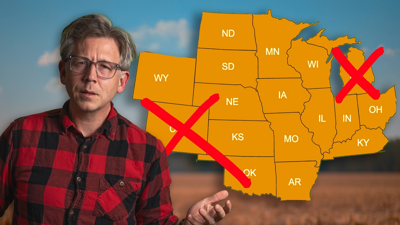
The Midwest, explained by maps, data, and history: in this video I hunt for the most Midwestern state. I compare classic census definitions with shifting cultural borders, then test “Midwestern-ness” using population density, basements and frost lines, snow-day cancellation thresholds, flatness, and Great Lakes proximity. I bring in corn and soybean maps, E85 stations, and Dairy Queen per-capita locations to capture food, farming, and everyday life. Along the way we talk pop vs soda, duck duck gray duck, and regional dialects that make the Upper Midwest sound the way it does.
History and identity matter too. I pull quotes from Timothy Flint (1833) and Abraham Lincoln’s “great interior region” to show how the Middle Western idea started. We look at Census Bureau regions, USPS operational maps, Interior/NPS watershed regions, and how agencies slice the country differently. I overlay modern surveys (FiveThirtyEight, YouGov) that ask Americans which states are Midwest, and map how groups shaped the region: German ancestry, the Great Migration, Hmong and Somali communities in Minnesota, Arab Americans in Michigan, and more.
Then I run a 10-round tournament ranking states by the most persuasive maps and the poll you all answered. Geography, climate, agriculture, turnout, slang, and chains all count. Minnesota, Iowa, Wisconsin, Nebraska rise and fall as each round lands, and we end with a data-driven winner for “the most Midwestern state.” If you like map-based explainers about regional identity, language, and history, this is the definitive Midwest breakdown. Share your tweaks, argue in the comments, and check the newsletter for sources and extra maps.
Find me elsewhere:
Instagram: https://www.instagram.com/philedwardsinc/
Twitter: https://twitter.com/philedwardsinc
Patreon: https://www.patreon.com/philedwardsinc
Some music by the inimitable Tom Fox via Chromatic: https://tfbeats.com/
Where I get some music (Free trial affiliate link):
https://share.epidemicsound.com/olkrqv
My camera, as of February 2022 (affiliate link):
https://amzn.to/3HDcWVz
My main lens: https://amzn.to/3IteXEK
My main light: https://amzn.to/3pjO0M8
My main light accessory: https://amzn.to/3M6eL0j


@PhilEdwardsInc
June 13, 2026 at 3:52 pm
Download the FREE Upside App at https://upside.app.link/philedwards to get an extra 25 cents back for every gallon on your first tank of gas.
@dippst
June 13, 2026 at 3:52 pm
you would get vastly different results if you exclude the chicago, detroit and milwaukee metro areas. each of those metros account for a large percentage of the respective state's populations, but a disproportionate percentage of transplants from outside of the midwest.
@BadClown_YT
June 13, 2026 at 3:52 pm
Im from Michigan, and i do think Michigan is more of THE Great Lake State, rather then THE Midwest State, but its definitely up there
@WhackaWhacka2
June 13, 2026 at 3:52 pm
Midwest shouldn't conform to state borders. One of the reasons I would pick Iowa is that most other midwestern states have areas that have more in common with other regions, or even countries in the case of the far north.
@notamexican91
June 13, 2026 at 3:52 pm
Anything east of the Mississippi River or west of kansas is not the Midwest. Please reeducate yourself.
@Jasper118
June 13, 2026 at 3:52 pm
Colorado on there at the beginning was grinding my skin…as a Coloradan and former Illinoisan. It’s more Californian than California now.
@creativetravelerfm
June 13, 2026 at 3:52 pm
I missed your reason why you left North Dakota out of the list
@cornvrgt
June 13, 2026 at 3:52 pm
22:21 “Missouruh”
@Dubuqueland
June 13, 2026 at 3:52 pm
Driftless Area
The Heart of the Midwest
@Dubuqueland
June 13, 2026 at 3:52 pm
Upper Mississippi River Valley
@Dubuqueland
June 13, 2026 at 3:52 pm
Luxemburg, Iowa
Luxemburg, Wisconsin
Luxemburg, Minnesota
Lëtzebuerg Rules!
@briantbmoth6472
June 13, 2026 at 3:52 pm
“Kitty corner” is the Midwest! I thought everyone used that description. I say “pop”.
@briantbmoth6472
June 13, 2026 at 3:52 pm
Colorado is too far West to be Midwest. Ohio is the beginning of Midwest because of the Appalachian mountains.
@andrewpulda7969
June 13, 2026 at 3:52 pm
Life long Cheesehead (58yrs) Wy and Col are "mountain west", Ky and Ar are "southern" Tx is both "Southwest" and "Southern", Okl. is ??? but not Midwest. So just to start those 6 states are not midwest. Midwest states are Oh, In, Il, Ia, Mo, Ka, Ne, Sd, Nd, Mn, Wi, Mi.Most midwest (1-5)state is IA, In, Neb, Ill, and WI.
@jelsner5077
June 13, 2026 at 3:52 pm
As a born-and-bred Minnesotan, I remember as a child in the late 60s and 70s my state being called the "Upper Midwest," or the "Northwest," as in Northwest Orient Airlines (later changed to Northwest Airlines, centered in Minneapolis).
@gnaydenfry1503
June 13, 2026 at 3:52 pm
We all know Iowa doesn't lose to Minnesota in anything
@brandonm6052
June 13, 2026 at 3:52 pm
As a Nebraskan im going with The Beef State….or a plains state. But will loosely identify with most midwestern generalities
@brianwilliam1869
June 13, 2026 at 3:52 pm
If you’re not in the central time zone, you’re not in the Midwest. Also if you he live around Ohio, sorry but you live in a the Middle East.
@depressedbananabreadofficial
June 13, 2026 at 3:52 pm
I like to think that Iowa is the Midwestest. It was really close, and Iowa is more mid. I mean that Minnesota is Northern, and Iowa is more towards the middle.
@gregorystacey3441
June 13, 2026 at 3:52 pm
Corn and soybean production is deceptive as Wisconsin mainly only grows these crops in southern half. Part is geography and part is due to forests. Much of your data was confounded as they were not mutually exclusive. Flatness and crop production are highly correlated
@JacksonDoesThings-26
June 13, 2026 at 3:52 pm
You said Wisconsin wrong, you’re supposed to say it wiscawnsin
@jcbehnke
June 13, 2026 at 3:52 pm
Yea these rankings are pretty absurd. Ohio, Indiana, Iowa are ultimate Midwest. Probably the top three states any rando in the country would give you. Minnesota voted Mondale and has been actively trying to fall into the ocean along with the entire west coast. Minnesota is NOT Midwest. It’s Canada.
@jamesharris9403
June 13, 2026 at 3:52 pm
Nothing west of Iowa is Midwest. While IN, MO, and OH are technically in the Midwest, they are actually southern states 😬
@SullivanHarlan
June 13, 2026 at 3:52 pm
Iowa is more Midwestern then Minnesota